


grant tour d eyrole

losjo
User
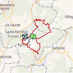

Length
16.4 km

Max alt
803 m

Uphill gradient
675 m
Km-Effort
25 km

Min alt
466 m

Downhill gradient
675 m
Boucle
Yes
Creation date :
2018-04-17 11:01:46.515
Updated on :
2018-04-17 11:01:46.515
5h58
Difficulty : Medium

FREE GPS app for hiking
 SityTrail
IGN / Geographical institutes
SityTrail Plus
The world is yours!
About
Trail Walking of 16.4 km to be discovered at Auvergne-Rhône-Alpes, Drôme, Eyroles. This trail is proposed by losjo.
Positioning
Country:
France
Region :
Auvergne-Rhône-Alpes
Department/Province :
Drôme
Municipality :
Eyroles
Location:
Unknown
Start:(Dec)
Start:(UTM)
677713 ; 4920824 (31T) N.
Comments