


W - 2018 - 39 Sully Thury

clabidault
User
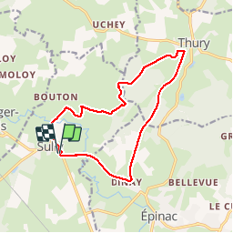

Length
14 km

Max alt
451 m

Uphill gradient
211 m
Km-Effort
16.8 km

Min alt
310 m

Downhill gradient
211 m
Boucle
Yes
Creation date :
2018-04-17 11:09:34.475
Updated on :
2018-12-30 16:12:45.525
3h39
Difficulty : Easy

FREE GPS app for hiking
 SityTrail
IGN / Geographical institutes
SityTrail Plus
The world is yours!
About
Trail Walking of 14 km to be discovered at Bourgogne-Franche-Comté, Saône-et-Loire, Sully. This trail is proposed by clabidault.
Positioning
Country:
France
Region :
Bourgogne-Franche-Comté
Department/Province :
Saône-et-Loire
Municipality :
Sully
Location:
Unknown
Start:(Dec)
Start:(UTM)
612077 ; 5206785 (31T) N.
Comments