


balazuc avec meyras

raab
User
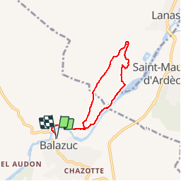

Length
6.4 km

Max alt
238 m

Uphill gradient
172 m
Km-Effort
8.8 km

Min alt
129 m

Downhill gradient
177 m
Boucle
Yes
Creation date :
2018-07-30 16:23:28.654
Updated on :
2018-07-30 16:23:28.67
1h59
Difficulty : Easy

FREE GPS app for hiking
 SityTrail
IGN / Geographical institutes
SityTrail Plus
The world is yours!
About
Trail Walking of 6.4 km to be discovered at Auvergne-Rhône-Alpes, Ardèche, Balazuc. This trail is proposed by raab.
Positioning
Country:
France
Region :
Auvergne-Rhône-Alpes
Department/Province :
Ardèche
Municipality :
Balazuc
Location:
Unknown
Start:(Dec)
Start:(UTM)
609097 ; 4929473 (31T) N.
Comments