


Le Vaudoué Rocher de Cahière

BrassensJC
User
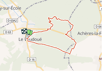

Length
7.6 km

Max alt
126 m

Uphill gradient
139 m
Km-Effort
9.4 km

Min alt
72 m

Downhill gradient
131 m
Boucle
Yes
Creation date :
2018-04-17 11:19:36.458
Updated on :
2018-04-17 11:19:36.458
2h03
Difficulty : Medium

FREE GPS app for hiking
 SityTrail
IGN / Geographical institutes
SityTrail Plus
The world is yours!
About
Trail Walking of 7.6 km to be discovered at Ile-de-France, Seine-et-Marne, Le Vaudoué. This trail is proposed by BrassensJC.
Positioning
Country:
France
Region :
Ile-de-France
Department/Province :
Seine-et-Marne
Municipality :
Le Vaudoué
Location:
Unknown
Start:(Dec)
Start:(UTM)
464392 ; 5355892 (31U) N.
Comments