


Clairlieu_16kms

ZAMBAUX
User
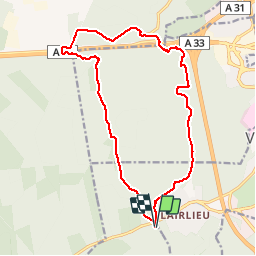

Length
16.3 km

Max alt
387 m

Uphill gradient
268 m
Km-Effort
19.9 km

Min alt
267 m

Downhill gradient
269 m
Boucle
Yes
Creation date :
2019-04-27 09:34:47.005
Updated on :
2019-04-27 09:34:47.043
4h18
Difficulty : Unknown

FREE GPS app for hiking
 SityTrail
IGN / Geographical institutes
SityTrail Plus
The world is yours!
About
Trail Walking of 16.3 km to be discovered at Grand Est, Meurthe-et-Moselle, Chaligny. This trail is proposed by ZAMBAUX.
Positioning
Country:
France
Region :
Grand Est
Department/Province :
Meurthe-et-Moselle
Municipality :
Chaligny
Location:
Unknown
Start:(Dec)
Start:(UTM)
286657 ; 5392932 (32U) N.
Comments