


laberliere

NESTOR2714
User
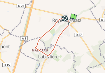

Length
4.5 km

Max alt
73 m

Uphill gradient
23 m
Km-Effort
4.8 km

Min alt
61 m

Downhill gradient
21 m
Boucle
Yes
Creation date :
2018-04-17 11:34:01.339
Updated on :
2018-04-17 11:34:01.339
1h10
Difficulty : Unknown

FREE GPS app for hiking
 SityTrail
IGN / Geographical institutes
SityTrail Plus
The world is yours!
About
Trail Other activity of 4.5 km to be discovered at Hauts-de-France, Oise, Roye-sur-Matz. This trail is proposed by NESTOR2714.
Positioning
Country:
France
Region :
Hauts-de-France
Department/Province :
Oise
Municipality :
Roye-sur-Matz
Location:
Unknown
Start:(Dec)
Start:(UTM)
483710 ; 5493268 (31U) N.
Comments