


petit parcours dombes atscaf

jpfrobert
User
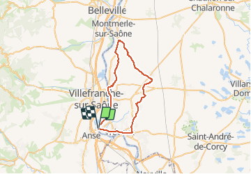

Length
41 km

Max alt
274 m

Uphill gradient
432 m
Km-Effort
47 km

Min alt
166 m

Downhill gradient
432 m
Boucle
Yes
Creation date :
2018-04-17 11:35:53.022
Updated on :
2018-04-17 11:35:53.022
--
Difficulty : Easy

FREE GPS app for hiking
 SityTrail
IGN / Geographical institutes
SityTrail Plus
The world is yours!
About
Trail Cycle of 41 km to be discovered at Auvergne-Rhône-Alpes, Ain, Saint-Bernard. This trail is proposed by jpfrobert.
Positioning
Country:
France
Region :
Auvergne-Rhône-Alpes
Department/Province :
Ain
Municipality :
Saint-Bernard
Location:
Unknown
Start:(Dec)
Start:(UTM)
634279 ; 5089392 (31T) N.
Comments