


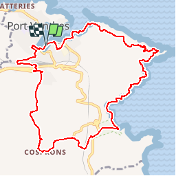
Port vendres-paulilles

rene06530
User

Length
12.5 km

Max alt
138 m

Uphill gradient
330 m
Km-Effort
16.9 km

Min alt
0 m

Downhill gradient
331 m
Boucle
Yes
Creation date :
2018-04-17 11:47:16.544
Updated on :
2018-04-17 11:47:16.544
4h00
Difficulty : Medium

FREE GPS app for hiking
 SityTrail
IGN / Geographical institutes
SityTrail Plus
The world is yours!
About
Trail Other activity of 12.5 km to be discovered at Occitania, Pyrénées-Orientales, Port-Vendres. This trail is proposed by rene06530.
Description
Port vendres, Gospron, Paulilles, cap Bear, Port Vendres.
Positioning
Country:
France
Region :
Occitania
Department/Province :
Pyrénées-Orientales
Municipality :
Port-Vendres
Location:
Unknown
Start:(Dec)
Start:(UTM)
508850 ; 4707141 (31T) N.
Comments