


bréche de Charance

MarcVachet
User
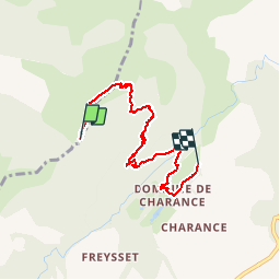

Length
6.2 km

Max alt
1729 m

Uphill gradient
72 m
Km-Effort
9.2 km

Min alt
1052 m

Downhill gradient
676 m
Boucle
No
Creation date :
2018-04-17 12:06:08.307
Updated on :
2018-04-17 12:06:08.307
2h11
Difficulty : Unknown

FREE GPS app for hiking
 SityTrail
IGN / Geographical institutes
SityTrail Plus
The world is yours!
About
Trail Other activity of 6.2 km to be discovered at Provence-Alpes-Côte d'Azur, Hautes-Alpes, Rabou. This trail is proposed by MarcVachet.
Positioning
Country:
France
Region :
Provence-Alpes-Côte d'Azur
Department/Province :
Hautes-Alpes
Municipality :
Rabou
Location:
Unknown
Start:(Dec)
Start:(UTM)
265087 ; 4941147 (32T) N.
Comments