


beau vol

DPICHOT
User
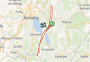

Length
70 km

Max alt
1803 m

Uphill gradient
7032 m
Km-Effort
165 km

Min alt
447 m

Downhill gradient
7465 m
Boucle
No
Creation date :
2018-04-17 12:20:20.134
Updated on :
2018-04-17 12:20:20.134
--
Difficulty : Easy

FREE GPS app for hiking
 SityTrail
IGN / Geographical institutes
SityTrail Plus
The world is yours!
About
Trail Running of 70 km to be discovered at Auvergne-Rhône-Alpes, Upper Savoy, Talloires-Montmin. This trail is proposed by DPICHOT.
Positioning
Country:
France
Region :
Auvergne-Rhône-Alpes
Department/Province :
Upper Savoy
Municipality :
Talloires-Montmin
Location:
Talloires
Start:(Dec)
Start:(UTM)
284562 ; 5081510 (32T) N.
Comments