


Lac de Lavellan Mont Vinaigre 3544 ET

verotrail
User
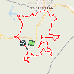

Length
13.2 km

Max alt
590 m

Uphill gradient
555 m
Km-Effort
21 km

Min alt
176 m

Downhill gradient
565 m
Boucle
Yes
Creation date :
2018-04-17 12:29:08.109
Updated on :
2018-04-17 12:29:08.109
4h23
Difficulty : Medium

FREE GPS app for hiking
 SityTrail
IGN / Geographical institutes
SityTrail Plus
The world is yours!
About
Trail Walking of 13.2 km to be discovered at Provence-Alpes-Côte d'Azur, Var, Fréjus. This trail is proposed by verotrail.
Positioning
Country:
France
Region :
Provence-Alpes-Côte d'Azur
Department/Province :
Var
Municipality :
Fréjus
Location:
Unknown
Start:(Dec)
Start:(UTM)
322292 ; 4818298 (32T) N.
Comments