


roc du diable

jean-charlesSIMAND
User
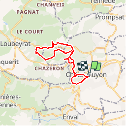

Length
12.5 km

Max alt
666 m

Uphill gradient
574 m
Km-Effort
20 km

Min alt
415 m

Downhill gradient
574 m
Boucle
Yes
Creation date :
2018-04-17 12:40:26.01
Updated on :
2018-04-17 12:40:26.01
1h46
Difficulty : Medium

FREE GPS app for hiking
 SityTrail
IGN / Geographical institutes
SityTrail Plus
The world is yours!
About
Trail Running of 12.5 km to be discovered at Auvergne-Rhône-Alpes, Puy-de-Dôme, Châtel-Guyon. This trail is proposed by jean-charlesSIMAND.
Positioning
Country:
France
Region :
Auvergne-Rhône-Alpes
Department/Province :
Puy-de-Dôme
Municipality :
Châtel-Guyon
Location:
Unknown
Start:(Dec)
Start:(UTM)
504908 ; 5085106 (31T) N.
Comments