


Hiv2018-20-V2B

PhilippeC54
User
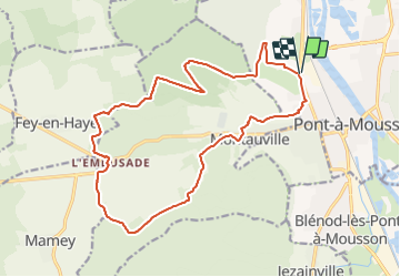

Length
18.3 km

Max alt
373 m

Uphill gradient
345 m
Km-Effort
23 km

Min alt
175 m

Downhill gradient
345 m
Boucle
Yes
Creation date :
2018-04-17 12:50:37.235
Updated on :
2018-04-17 12:50:37.235
1h31
Difficulty : Easy

FREE GPS app for hiking
 SityTrail
IGN / Geographical institutes
SityTrail Plus
The world is yours!
About
Trail Mountain bike of 18.3 km to be discovered at Grand Est, Meurthe-et-Moselle, Pont-à-Mousson. This trail is proposed by PhilippeC54.
Positioning
Country:
France
Region :
Grand Est
Department/Province :
Meurthe-et-Moselle
Municipality :
Pont-à-Mousson
Location:
Unknown
Start:(Dec)
Start:(UTM)
282960 ; 5422003 (32U) N.
Comments