


les sources de volvic

jeanic63
User
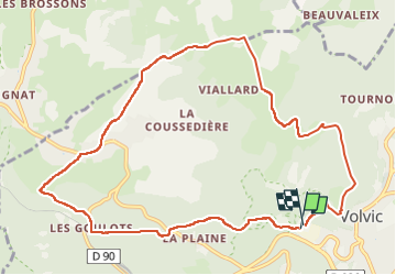

Length
11.2 km

Max alt
780 m

Uphill gradient
312 m
Km-Effort
15.4 km

Min alt
567 m

Downhill gradient
306 m
Boucle
Yes
Creation date :
2018-04-17 12:57:31.131
Updated on :
2023-03-02 17:59:21.116
2h48
Difficulty : Unknown

FREE GPS app for hiking
 SityTrail
IGN / Geographical institutes
SityTrail Plus
The world is yours!
About
Trail Other activity of 11.2 km to be discovered at Auvergne-Rhône-Alpes, Puy-de-Dôme, Volvic. This trail is proposed by jeanic63.
Description
départ parking des eaux de volvic
Positioning
Country:
France
Region :
Auvergne-Rhône-Alpes
Department/Province :
Puy-de-Dôme
Municipality :
Volvic
Location:
Unknown
Start:(Dec)
Start:(UTM)
502178 ; 5079743 (31T) N.
Comments