


2017 andreenne

olivier26
User
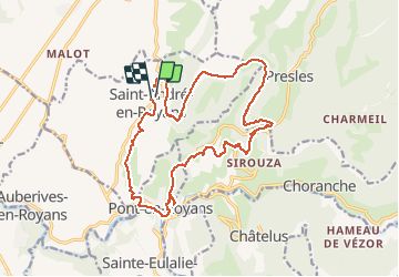

Length
19 km

Max alt
979 m

Uphill gradient
1035 m
Km-Effort
33 km

Min alt
195 m

Downhill gradient
1037 m
Boucle
Yes
Creation date :
2018-04-17 12:59:41.417
Updated on :
2018-04-17 12:59:41.417
--
Difficulty : Difficult

FREE GPS app for hiking
 SityTrail
IGN / Geographical institutes
SityTrail Plus
The world is yours!
About
Trail Walking of 19 km to be discovered at Auvergne-Rhône-Alpes, Isère, Saint-André-en-Royans. This trail is proposed by olivier26.
Positioning
Country:
France
Region :
Auvergne-Rhône-Alpes
Department/Province :
Isère
Municipality :
Saint-André-en-Royans
Location:
Unknown
Start:(Dec)
Start:(UTM)
684236 ; 4995231 (31T) N.
Comments