Trail Walking Gavarnie-Gèdre - Gavarnie circuit du gypaete/Fait - Photo

Gavarnie circuit du gypaete/Fait

convivialite, sport et fiesta

© OpenStreetMap contributors
Length
Length
9.2 km
Max alt
Max alt
1607 m
Uphill gradient
Uphill gradient
500 m
Km-Effort
Km-Effort  
15.8 km
Min alt
Min alt
1284 m
Downhill gradient
Downhill gradient
508 m
Boucle
Boucle
Yes
Signpost
Signpost
Creation date :
2019-04-29 08:27:17.047
Updated on :
2019-04-29 08:27:17.087

(0 Reviews)

Walking
Walking
3h35
Difficulty : Medium

Scan this QR Code to open this trail in the SityTrail application

FREE GPS app for hiking

Logo SityTrail SityTrail

IGN / Geographical institutes

Download SityTrail from the App Store Download SityTrail from Google Play

Logo SityTrail SityTrail Plus

The world is yours!

Download SityTrail from the App Store Download SityTrail from Google Play Download SityTrail on Huawei AppGallery

About

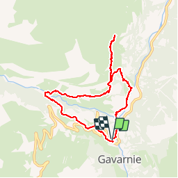
Trail Walking of 9.2 km to be discovered at Occitania, Hautespyrenees, Gavarnie-Gèdre. This trail is proposed by Lous Passa camins.

Description

Départ de la rando du village de gavarnie rte de la station 9h45 .
Arrivée PN premiere grange de saugue 12h15
Départ PN 13h15
a 13h45 on tournera a G direction gavarnie
Arrivée aux voitures 15h10

Elevation profile

Positioning

Country:
France
Region :
Occitania
Department/Province :
Hautespyrenees
Municipality :
Gavarnie-Gèdre
Location:
Gavarnie
Start:(UTM)
744644 ; 4735803 (30T) N.

Comments

Please log in to post a review or rate the element


Même si vous ne voyez pas de gypaète, allez faire cette rando vous ne serez pas déçu. Vous évoluez dans un décor grandiose avec en toile de fond le cirque de Gavarnie


Close
My subscriptions