


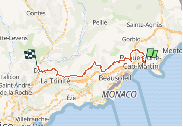
Via Aurelia de Roquebrune à Drap

PEBREJOSIANE
User

Length
22 km

Max alt
793 m

Uphill gradient
1019 m
Km-Effort
36 km

Min alt
21 m

Downhill gradient
943 m
Boucle
No
Creation date :
2018-04-17 13:03:26.856
Updated on :
2018-04-17 13:03:26.856
8h04
Difficulty : Easy

FREE GPS app for hiking
 SityTrail
IGN / Geographical institutes
SityTrail Plus
The world is yours!
About
Trail Walking of 22 km to be discovered at Provence-Alpes-Côte d'Azur, Maritime Alps, Roquebrune-Cap-Martin. This trail is proposed by PEBREJOSIANE.
Description
superbe rando avec des points de vue majestueux
Positioning
Country:
France
Region :
Provence-Alpes-Côte d'Azur
Department/Province :
Maritime Alps
Municipality :
Roquebrune-Cap-Martin
Location:
Unknown
Start:(Dec)
Start:(UTM)
376218 ; 4846474 (32T) N.
Comments