


Rochehaut Annif 2

rando1490
User
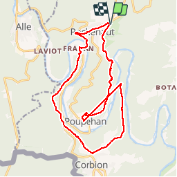

Length
17.8 km

Max alt
384 m

Uphill gradient
659 m
Km-Effort
27 km

Min alt
194 m

Downhill gradient
660 m
Boucle
Yes
Creation date :
2018-04-17 13:06:34.763
Updated on :
2018-04-17 13:06:34.763
5h37
Difficulty : Medium

FREE GPS app for hiking
 SityTrail
IGN / Geographical institutes
SityTrail Plus
The world is yours!
About
Trail Walking of 17.8 km to be discovered at Wallonia, Luxembourg, Bouillon. This trail is proposed by rando1490.
Description
Via les crêtes de Frahan
Positioning
Country:
Belgium
Region :
Wallonia
Department/Province :
Luxembourg
Municipality :
Bouillon
Location:
Rochehaut
Start:(Dec)
Start:(UTM)
644964 ; 5523115 (31U) N.
Comments