Trail Walking Chessy - Chessy-les-Mines (69) - Photo

Chessy-les-Mines (69)

© OpenStreetMap contributors
Length
Length
9.5 km
Max alt
Max alt
391 m
Uphill gradient
Uphill gradient
252 m
Km-Effort
Km-Effort  
12.9 km
Min alt
Min alt
214 m
Downhill gradient
Downhill gradient
252 m
Boucle
Boucle
Yes
Creation date :
2018-04-17 13:19:17.404
Updated on :
2018-04-17 13:19:17.404

(0 Reviews)

Walking
Walking
2h45
Difficulty : Easy

Scan this QR Code to open this trail in the SityTrail application

FREE GPS app for hiking

Logo SityTrail SityTrail

IGN / Geographical institutes

Download SityTrail from the App Store Download SityTrail from Google Play

Logo SityTrail SityTrail World

The world is yours!

Download SityTrail from the App Store Download SityTrail from Google Play Download SityTrail on Huawei AppGallery

About

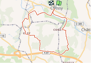
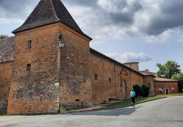
Trail Walking of 9.5 km to be discovered at Auvergne-Rhône-Alpes, Rhône, Chessy. This trail is proposed by Thomasdanielle.

Description

Départ parking de la mairie
Suivre l'avenue de la Gare vers la départementale. un passage souterrain permet de traverser la route et la voie ferrée. continuez sur l'avenue du stade. Prendre le chemin qui part sur la gauche le long du parc, suivez-le. Il se transforme en chemin de terre, se rapproche de la voie ferrée et arrive sur la route du Fay.

Elevation profile

Positioning

Country:
France
Region :
Auvergne-Rhône-Alpes
Department/Province :
Rhône
Municipality :
Chessy
Location:
Unknown
Start:(UTM)
625862 ; 5082769 (31T) N.

Trails nearby

Trail Mountain bike Lozanne - La 5ème Vélozannaise (2014-VTT-45km) - Lozanne - Photo
Mountain bike
tracegps

Mountain bike

Difficult
(1)
Lozanne, Auvergne-Rhône-Alpes, Rhône, France
45 km | 59 km-effort
3h 45min
Yes
Trail Horseback riding Bully - BULLY  nord 29k 38KF - Photo
Horseback riding
azipat

Horseback riding

Difficult
(1)
Bully, Auvergne-Rhône-Alpes, Rhône, France
30 km | 39 km-effort
5h 9min
Yes
Trail On foot Légny - De Saint Vérand à Bagnols - Photo
On foot
PRO

On foot

Easy
Légny, Auvergne-Rhône-Alpes, Rhône, France
7.4 km | 10.3 km-effort
2h 20min
No
Trail On foot Saint-Jean-des-Vignes - De Bagnols à Lozanne - Photo
On foot
PRO

On foot

Easy
Saint-Jean-des-Vignes, Auvergne-Rhône-Alpes, Rhône, France
4 km | 5 km-effort
1h 7min
No
Trail On foot Lozanne - De Lozanne à Marcy - Photo
On foot
PRO

On foot

Easy
Lozanne, Auvergne-Rhône-Alpes, Rhône, France
12.2 km | 15.6 km-effort
3h 32min
No
Trail Nordic walking Bagnols - bagnol - Photo
Nordic walking
isabelle.xavier

Nordic walking

Very easy
(1)
Bagnols, Auvergne-Rhône-Alpes, Rhône, France
6.8 km | 8.4 km-effort
1h 40min
Yes
Trail Walking Saint-Jean-des-Vignes - A_ST JEAN DES VIGNES 69380 Pierre Folle - Fontainebleau - Photo
Walking
ANDREJAC

Walking

Easy
(1)
Saint-Jean-des-Vignes, Auvergne-Rhône-Alpes, Rhône, France
8 km | 11 km-effort
3h 0min
Yes
Trail Walking Chessy - Chessy à Bagnols - Photo
Walking
Jean-Marc C

Walking

Difficult
(1)
Chessy, Auvergne-Rhône-Alpes, Rhône, France
12.5 km | 15.8 km-effort
3h 35min
Yes
Trail Walking Charnay - Charnay (12 km - D. 330 m) - Photo
Walking
Thomasdanielle

Walking

Easy
Charnay, Auvergne-Rhône-Alpes, Rhône, France
12.5 km | 16.9 km-effort
3h 7min
Yes


Close
My subscriptions