


le puy de cevelou

jeanic63
User
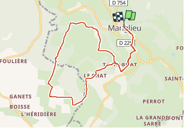

Length
10.7 km

Max alt
532 m

Uphill gradient
201 m
Km-Effort
13.4 km

Min alt
423 m

Downhill gradient
203 m
Boucle
Yes
Creation date :
2018-04-17 13:22:00.157
Updated on :
2021-04-11 13:26:35.95
2h43
Difficulty : Unknown

FREE GPS app for hiking
 SityTrail
IGN / Geographical institutes
SityTrail Plus
The world is yours!
About
Trail Other activity of 10.7 km to be discovered at Auvergne-Rhône-Alpes, Puy-de-Dôme, Manglieu. This trail is proposed by jeanic63.
Description
départ église de Manglieu 63
Positioning
Country:
France
Region :
Auvergne-Rhône-Alpes
Department/Province :
Puy-de-Dôme
Municipality :
Manglieu
Location:
Unknown
Start:(Dec)
Start:(UTM)
527344 ; 5050967 (31T) N.
Comments