


Jouy le moutier à Cergy par le chemin des miettes puis retour le long de l'Oise

Rain95
User
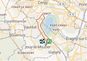

Length
9.3 km

Max alt
82 m

Uphill gradient
139 m
Km-Effort
11.1 km

Min alt
18 m

Downhill gradient
139 m
Boucle
Yes
Creation date :
2018-04-17 13:31:11.854
Updated on :
2018-04-17 13:31:11.854
2h04
Difficulty : Easy

FREE GPS app for hiking
 SityTrail
IGN / Geographical institutes
SityTrail Plus
The world is yours!
About
Trail Walking of 9.3 km to be discovered at Ile-de-France, Val-d'Oise, Jouy-le-Moutier. This trail is proposed by Rain95.
Description
Randonnée d'automne
Photos


Positioning
Country:
France
Region :
Ile-de-France
Department/Province :
Val-d'Oise
Municipality :
Jouy-le-Moutier
Location:
Unknown
Start:(Dec)
Start:(UTM)
430025 ; 5429197 (31U) N.
Comments