


Haïssotte

kikkko
User
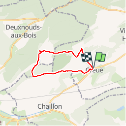

Length
8.9 km

Max alt
399 m

Uphill gradient
234 m
Km-Effort
12.1 km

Min alt
272 m

Downhill gradient
236 m
Boucle
Yes
Creation date :
2018-04-17 13:41:42.634
Updated on :
2018-04-17 13:41:42.634
2h28
Difficulty : Easy

FREE GPS app for hiking
 SityTrail
IGN / Geographical institutes
SityTrail Plus
The world is yours!
About
Trail Walking of 8.9 km to be discovered at Grand Est, Meuse, Vigneulles-lès-Hattonchâtel. This trail is proposed by kikkko.
Description
Joli parcours qui permet de découvrir l'abbaye de l'Etanche
Positioning
Country:
France
Region :
Grand Est
Department/Province :
Meuse
Municipality :
Vigneulles-lès-Hattonchâtel
Location:
Unknown
Start:(Dec)
Start:(UTM)
695430 ; 5427029 (31U) N.
Comments