


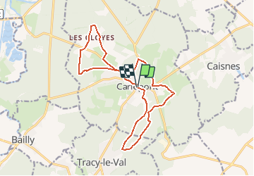
Circuit des Evêques - Carlepont

NESTOR2714
User


4h00
Difficulty : Difficult

FREE GPS app for hiking
 SityTrail
IGN / Geographical institutes
SityTrail Plus
The world is yours!
About
Trail Walking of 15.7 km to be discovered at Hauts-de-France, Oise, Carlepont. This trail is proposed by NESTOR2714.
Description
Circuit proposé par le Pays Noyonnais. Départ de la Place de l'église de Carlepont. Retrouvez le descriptif du circuit sur le site du Pays Noyonnais. Ce circuit a été numérisé par les randonneurs du CODEPEM. Merci à Jean-Marie.
Positioning
Comments