Trail Walking Saint-Bertrand-de-Comminges - Sant-Bertrand de Cominges mail de hard fait le 10/11/17 - Photo

Sant-Bertrand de Cominges mail de hard fait le 10/11/17

convivialite, sport et fiesta

© OpenStreetMap contributors
Length
Length
11.1 km
Max alt
Max alt
819 m
Uphill gradient
Uphill gradient
547 m
Km-Effort
Km-Effort  
18.4 km
Min alt
Min alt
456 m
Downhill gradient
Downhill gradient
547 m
Boucle
Boucle
Yes
Creation date :
2019-04-29 08:27:16.158
Updated on :
2019-04-29 08:27:16.195

(0 Reviews)

Walking
Walking
3h45
Difficulty : Easy

Scan this QR Code to open this trail in the SityTrail application

FREE GPS app for hiking

Logo SityTrail SityTrail

IGN / Geographical institutes

Download SityTrail from the App Store Download SityTrail from Google Play

Logo SityTrail SityTrail Plus

The world is yours!

Download SityTrail from the App Store Download SityTrail from Google Play Download SityTrail on Huawei AppGallery

About

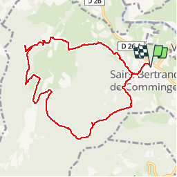
Trail Walking of 11.1 km to be discovered at Occitania, Haute-Garonne, Saint-Bertrand-de-Comminges. This trail is proposed by Lous Passa camins.

Description

Tres belle balade, à faire de préférence sur terrain sec.
faites un détour au gouffre de l'aspugues ou vous profiterez des rochers pour établir le PN
Départ à 9h du grand parking de Saint Bertrand de comminges PN 13h retour 15h45

Elevation profile

Positioning

Country:
France
Region :
Occitania
Department/Province :
Haute-Garonne
Municipality :
Saint-Bertrand-de-Comminges
Location:
Unknown
Start:(UTM)
302188 ; 4766926 (31T) N.


Close
My subscriptions