


Maron-les falaises bis

geranimo
User
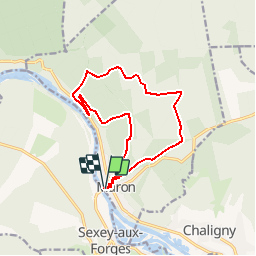

Length
12.8 km

Max alt
393 m

Uphill gradient
318 m
Km-Effort
17 km

Min alt
218 m

Downhill gradient
320 m
Boucle
Yes
Creation date :
2018-04-17 13:56:36.902
Updated on :
2018-04-17 13:56:36.902
3h42
Difficulty : Medium

FREE GPS app for hiking
 SityTrail
IGN / Geographical institutes
SityTrail Plus
The world is yours!
About
Trail Walking of 12.8 km to be discovered at Grand Est, Meurthe-et-Moselle, Maron. This trail is proposed by geranimo.
Positioning
Country:
France
Region :
Grand Est
Department/Province :
Meurthe-et-Moselle
Municipality :
Maron
Location:
Unknown
Start:(Dec)
Start:(UTM)
282270 ; 5391112 (32U) N.
Comments