


Somt.château de la Vière

rigol05
User
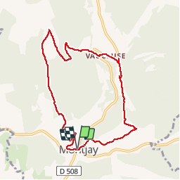

Length
9.1 km

Max alt
1085 m

Uphill gradient
438 m
Km-Effort
15 km

Min alt
792 m

Downhill gradient
438 m
Boucle
Yes
Creation date :
2018-04-17 14:17:12.793
Updated on :
2018-04-17 14:17:12.793
3h04
Difficulty : Medium

FREE GPS app for hiking
 SityTrail
IGN / Geographical institutes
SityTrail Plus
The world is yours!
About
Trail Walking of 9.1 km to be discovered at Provence-Alpes-Côte d'Azur, Hautes-Alpes, Montjay. This trail is proposed by rigol05.
Description
Sortie du 07/12/2017Itinéraire modifié pour cause de neige.
Positioning
Country:
France
Region :
Provence-Alpes-Côte d'Azur
Department/Province :
Hautes-Alpes
Municipality :
Montjay
Location:
Unknown
Start:(Dec)
Start:(UTM)
707624 ; 4915172 (31T) N.
Comments