


thil

doudet
User
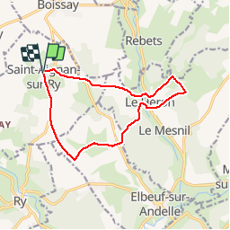

Length
11.7 km

Max alt
168 m

Uphill gradient
288 m
Km-Effort
15.5 km

Min alt
81 m

Downhill gradient
288 m
Boucle
Yes
Creation date :
2018-09-11 09:10:44.395
Updated on :
2018-09-11 09:10:44.395
--
Difficulty : Medium

FREE GPS app for hiking
 SityTrail
IGN / Geographical institutes
SityTrail Plus
The world is yours!
About
Trail Walking of 11.7 km to be discovered at Normandy, Seine-Maritime, Saint-Aignan-sur-Ry. This trail is proposed by doudet.
Positioning
Country:
France
Region :
Normandy
Department/Province :
Seine-Maritime
Municipality :
Saint-Aignan-sur-Ry
Location:
Unknown
Start:(Dec)
Start:(UTM)
380698 ; 5484709 (31U) N.
Comments