


076-110 -Clères le Bocasse 13km-876-715-

rvs147
User
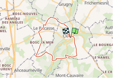

Length
12.8 km

Max alt
185 m

Uphill gradient
239 m
Km-Effort
16 km

Min alt
73 m

Downhill gradient
238 m
Boucle
Yes
Creation date :
2018-04-17 14:46:37.813
Updated on :
2022-09-20 16:03:56.857
8m
Difficulty : Medium

FREE GPS app for hiking
 SityTrail
IGN / Geographical institutes
SityTrail Plus
The world is yours!
About
Trail Walking of 12.8 km to be discovered at Normandy, Seine-Maritime, Clères. This trail is proposed by rvs147.
Photos

Positioning
Country:
France
Region :
Normandy
Department/Province :
Seine-Maritime
Municipality :
Clères
Location:
Unknown
Start:(Dec)
Start:(UTM)
363473 ; 5495615 (31U) N.
Comments
CLERES - LE BOCASSE - Version nouvelle