


Vienne en Val Sud 20171222

lemuid
User
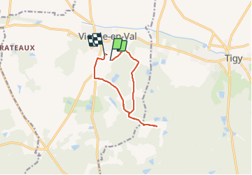

Length
9.6 km

Max alt
149 m

Uphill gradient
99 m
Km-Effort
10.9 km

Min alt
109 m

Downhill gradient
99 m
Boucle
No
Creation date :
2018-04-17 15:00:59.593
Updated on :
2018-04-17 15:00:59.593
2h24
Difficulty : Easy

FREE GPS app for hiking
 SityTrail
IGN / Geographical institutes
SityTrail Plus
The world is yours!
About
Trail Walking of 9.6 km to be discovered at Centre-Loire Valley, Loiret, Vienne-en-Val. This trail is proposed by lemuid.
Positioning
Country:
France
Region :
Centre-Loire Valley
Department/Province :
Loiret
Municipality :
Vienne-en-Val
Location:
Unknown
Start:(Dec)
Start:(UTM)
435593 ; 5293793 (31T) N.
Comments