


Rando

trailer.nono
User

Length
46 km

Max alt
529 m

Uphill gradient
996 m
Km-Effort
59 km

Min alt
12 m

Downhill gradient
996 m
Boucle
Yes
Creation date :
2018-04-17 15:03:29.882
Updated on :
2018-04-17 15:03:29.882
2h35
Difficulty : Medium

FREE GPS app for hiking
 SityTrail
IGN / Geographical institutes
SityTrail Plus
The world is yours!
About
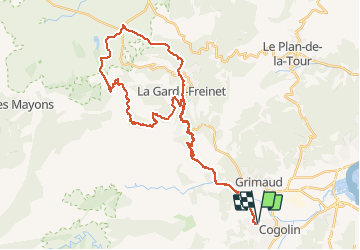
Trail Mountain bike of 46 km to be discovered at Provence-Alpes-Côte d'Azur, Var, Cogolin. This trail is proposed by trailer.nono.
Positioning
Country:
France
Region :
Provence-Alpes-Côte d'Azur
Department/Province :
Var
Municipality :
Cogolin
Location:
Unknown
Start:(Dec)
Start:(UTM)
298832 ; 4791917 (32T) N.
Comments