


AUTOUR DE PREMANON 18K

UDGI54
User
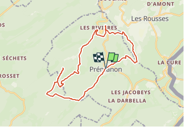

Length
17.9 km

Max alt
1291 m

Uphill gradient
703 m
Km-Effort
27 km

Min alt
859 m

Downhill gradient
702 m
Boucle
Yes
Creation date :
2018-04-17 15:30:45.502
Updated on :
2018-04-17 15:30:45.502
5h00
Difficulty : Unknown

FREE GPS app for hiking
 SityTrail
IGN / Geographical institutes
SityTrail Plus
The world is yours!
About
Trail Walking of 17.9 km to be discovered at Bourgogne-Franche-Comté, Jura. This trail is proposed by UDGI54.


Positioning
Country:
France
Region :
Bourgogne-Franche-Comté
Department/Province :
Jura
Municipality :
PREMANON
Location:
Unknown
Start:(Dec)
Start:(UTM)
272012 ; 5149683 (32T) N.
Comments