


Chapelle des Bures 2016

PhilippeC54
User
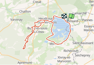

Length
39 km

Max alt
404 m

Uphill gradient
467 m
Km-Effort
46 km

Min alt
221 m

Downhill gradient
468 m
Boucle
Yes
Creation date :
2018-04-17 16:03:30.002
Updated on :
2018-04-17 16:03:30.002
3h04
Difficulty : Medium

FREE GPS app for hiking
 SityTrail
IGN / Geographical institutes
SityTrail Plus
The world is yours!
About
Trail Mountain bike of 39 km to be discovered at Grand Est, Meuse, Nonsard-Lamarche. This trail is proposed by PhilippeC54.
Description
Départ Nonsard
Positioning
Country:
France
Region :
Grand Est
Department/Province :
Meuse
Municipality :
Nonsard-Lamarche
Location:
Unknown
Start:(Dec)
Start:(UTM)
701601 ; 5423235 (31U) N.
Comments