


Venasque

MarcLEBARON
User
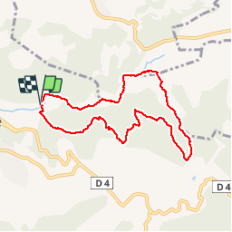

Length
8.2 km

Max alt
417 m

Uphill gradient
312 m
Km-Effort
12.3 km

Min alt
187 m

Downhill gradient
313 m
Boucle
Yes
Creation date :
2018-04-17 16:04:55.375
Updated on :
2018-04-17 16:04:55.375
2h13
Difficulty : Easy

FREE GPS app for hiking
 SityTrail
IGN / Geographical institutes
SityTrail Plus
The world is yours!
About
Trail Walking of 8.2 km to be discovered at Provence-Alpes-Côte d'Azur, Vaucluse, Venasque. This trail is proposed by MarcLEBARON.
Description
Boucle fond de Nesque, Combe du Diable, Chinardon.
Photos


Positioning
Country:
France
Region :
Provence-Alpes-Côte d'Azur
Department/Province :
Vaucluse
Municipality :
Venasque
Location:
Unknown
Start:(Dec)
Start:(UTM)
673175 ; 4873971 (31T) N.
Comments