LABASTIDE-DENAT

CANON2
User
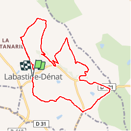

Length
10.5 km

Max alt
327 m

Uphill gradient
252 m
Km-Effort
13.9 km

Min alt
231 m

Downhill gradient
250 m
Boucle
Yes
Creation date :
2019-05-15 13:07:51.349
Updated on :
2019-05-15 13:07:51.554
2h56
Difficulty : Easy

FREE GPS app for hiking
 SityTrail
IGN / Geographical institutes
SityTrail Plus
The world is yours!
About
Trail Walking of 10.5 km to be discovered at Occitania, Tarn, Puygouzon. This trail is proposed by CANON2.
Positioning
Country:
France
Region :
Occitania
Department/Province :
Tarn
Municipality :
Puygouzon
Location:
Unknown
Start:(Dec)
Start:(UTM)
435036 ; 4857474 (31T) N.
Comments