


CHAUVIGNE ROMAZY

coglais
User
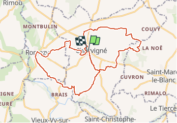

Length
21 km

Max alt
115 m

Uphill gradient
216 m
Km-Effort
24 km

Min alt
44 m

Downhill gradient
216 m
Boucle
Yes
Creation date :
2018-04-17 16:20:27.196
Updated on :
2020-10-28 15:55:51.466
3h00
Difficulty : Unknown

FREE GPS app for hiking
 SityTrail
IGN / Geographical institutes
SityTrail Plus
The world is yours!
About
Trail Nordic walking of 21 km to be discovered at Brittany, Ille-et-Vilaine, Chauvigné. This trail is proposed by coglais.
Positioning
Country:
France
Region :
Brittany
Department/Province :
Ille-et-Vilaine
Municipality :
Chauvigné
Location:
Unknown
Start:(Dec)
Start:(UTM)
613906 ; 5359263 (30U) N.
Comments