


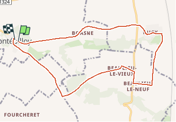
Montepilloy 10.3 km

GOELERANDO2
User

Length
10.3 km

Max alt
151 m

Uphill gradient
117 m
Km-Effort
11.9 km

Min alt
89 m

Downhill gradient
115 m
Boucle
Yes
Creation date :
2018-04-17 16:22:34.211
Updated on :
2018-04-17 16:22:34.211
2h36
Difficulty : Medium

FREE GPS app for hiking
 SityTrail
IGN / Geographical institutes
SityTrail Plus
The world is yours!
About
Trail Walking of 10.3 km to be discovered at Hauts-de-France, Oise, Montépilloy. This trail is proposed by GOELERANDO2.
Description
Parking et départ de la tour Ruinée.
Positioning
Country:
France
Region :
Hauts-de-France
Department/Province :
Oise
Municipality :
Montépilloy
Location:
Unknown
Start:(Dec)
Start:(UTM)
478072 ; 5450757 (31U) N.
Comments