


CENGLE

tessonnierg
User
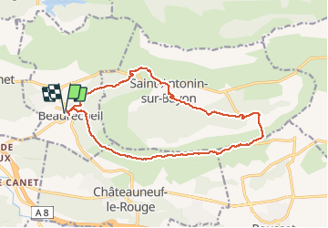

Length
17.1 km

Max alt
529 m

Uphill gradient
450 m
Km-Effort
23 km

Min alt
252 m

Downhill gradient
450 m
Boucle
Yes
Creation date :
2018-04-17 16:33:20.045
Updated on :
2018-04-17 16:33:20.045
5h00
Difficulty : Medium

FREE GPS app for hiking
 SityTrail
IGN / Geographical institutes
SityTrail Plus
The world is yours!
About
Trail Walking of 17.1 km to be discovered at Provence-Alpes-Côte d'Azur, Bouches-du-Rhône, Beaurecueil. This trail is proposed by tessonnierg.
Description
CENGLE
Positioning
Country:
France
Region :
Provence-Alpes-Côte d'Azur
Department/Province :
Bouches-du-Rhône
Municipality :
Beaurecueil
Location:
Unknown
Start:(Dec)
Start:(UTM)
705616 ; 4820823 (31T) N.
Comments