


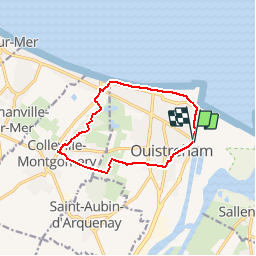
Ouistreham

phi14
User

Length
10.2 km

Max alt
28 m

Uphill gradient
59 m
Km-Effort
10.9 km

Min alt
0 m

Downhill gradient
57 m
Boucle
Yes
Creation date :
2018-04-17 16:42:56.076
Updated on :
2018-04-17 16:42:56.076
2h30
Difficulty : Easy

FREE GPS app for hiking
 SityTrail
IGN / Geographical institutes
SityTrail Plus
The world is yours!
About
Trail Walking of 10.2 km to be discovered at Normandy, Calvados, Ouistreham. This trail is proposed by phi14.
Description
Possibilité de rallonger le parcours en passant par Hermanville.
Positioning
Country:
France
Region :
Normandy
Department/Province :
Calvados
Municipality :
Ouistreham
Location:
Unknown
Start:(Dec)
Start:(UTM)
699964 ; 5462148 (30U) N.
Comments