


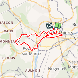
Chateau-Thierry Côte 204 13.6 km

GOELERANDO2
User

Length
13.6 km

Max alt
211 m

Uphill gradient
228 m
Km-Effort
16.6 km

Min alt
54 m

Downhill gradient
230 m
Boucle
Yes
Creation date :
2018-04-17 16:44:21.476
Updated on :
2018-04-17 16:44:21.476
3h36
Difficulty : Medium

FREE GPS app for hiking
 SityTrail
IGN / Geographical institutes
SityTrail Plus
The world is yours!
About
Trail Walking of 13.6 km to be discovered at Hauts-de-France, Aisne, Château-Thierry. This trail is proposed by GOELERANDO2.
Description
Parking et départ place des Etats Unis.
Positioning
Country:
France
Region :
Hauts-de-France
Department/Province :
Aisne
Municipality :
Château-Thierry
Location:
Unknown
Start:(Dec)
Start:(UTM)
529238 ; 5432427 (31U) N.
Comments