


lassigny 2301218

NESTOR2714
User
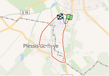

Length
2.8 km

Max alt
89 m

Uphill gradient
20 m
Km-Effort
3.1 km

Min alt
70 m

Downhill gradient
19 m
Boucle
Yes
Creation date :
2018-04-17 16:47:02.09
Updated on :
2018-04-17 16:47:02.09
40m
Difficulty : Unknown

FREE GPS app for hiking
 SityTrail
IGN / Geographical institutes
SityTrail Plus
The world is yours!
About
Trail Other activity of 2.8 km to be discovered at Hauts-de-France, Oise, Lassigny. This trail is proposed by NESTOR2714.
Description
marche
Positioning
Country:
France
Region :
Hauts-de-France
Department/Province :
Oise
Municipality :
Lassigny
Location:
Unknown
Start:(Dec)
Start:(UTM)
488333 ; 5492246 (31U) N.
Comments