


tour d horizon avec variante

tgvpatrickfavre
User
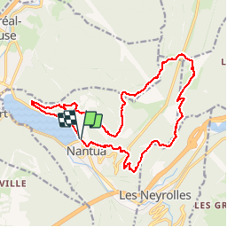

Length
19.5 km

Max alt
941 m

Uphill gradient
791 m
Km-Effort
30 km

Min alt
473 m

Downhill gradient
793 m
Boucle
Yes
Creation date :
2018-04-17 16:52:00.811
Updated on :
2019-12-07 11:34:55.746
5h23
Difficulty : Medium

FREE GPS app for hiking
 SityTrail
IGN / Geographical institutes
SityTrail Plus
The world is yours!
About
Trail Walking of 19.5 km to be discovered at Auvergne-Rhône-Alpes, Ain, Nantua. This trail is proposed by tgvpatrickfavre.
Description
tour d horizon avec passage par la prairie,molet et le gué du landeyron
Positioning
Country:
France
Region :
Auvergne-Rhône-Alpes
Department/Province :
Ain
Municipality :
Nantua
Location:
Unknown
Start:(Dec)
Start:(UTM)
701050 ; 5114735 (31T) N.
Comments