


Thiers S/Théve SM 8.2 km

GOELERANDO2
User
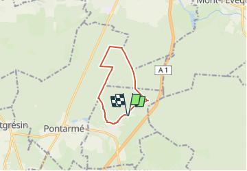

Length
8.2 km

Max alt
103 m

Uphill gradient
77 m
Km-Effort
9.2 km

Min alt
58 m

Downhill gradient
76 m
Boucle
Yes
Creation date :
2018-04-17 16:56:45.072
Updated on :
2018-04-17 16:56:45.072
2h01
Difficulty : Easy

FREE GPS app for hiking
 SityTrail
IGN / Geographical institutes
SityTrail Plus
The world is yours!
About
Trail Walking of 8.2 km to be discovered at Hauts-de-France, Oise, Thiers-sur-Thève. This trail is proposed by GOELERANDO2.
Positioning
Country:
France
Region :
Hauts-de-France
Department/Province :
Oise
Municipality :
Thiers-sur-Thève
Location:
Unknown
Start:(Dec)
Start:(UTM)
469567 ; 5445085 (31U) N.
Comments