


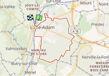
*L'Isle Adam en boucle

jpcccb
User

Length
15.2 km

Max alt
113 m

Uphill gradient
158 m
Km-Effort
17.3 km

Min alt
22 m

Downhill gradient
157 m
Boucle
Yes
Creation date :
2018-04-17 17:01:28.804
Updated on :
2024-08-20 16:26:41.36
3h56
Difficulty : Difficult

FREE GPS app for hiking
 SityTrail
IGN / Geographical institutes
SityTrail Plus
The world is yours!
About
Trail Walking of 15.2 km to be discovered at Ile-de-France, Val-d'Oise, Parmain. This trail is proposed by jpcccb.
Description
Forêt de l'Isle Adam, coteaux de l'Etang, porte Noire, Rond de l'Isle Adam, voie aux vaches.
Positioning
Country:
France
Region :
Ile-de-France
Department/Province :
Val-d'Oise
Municipality :
Parmain
Location:
Unknown
Start:(Dec)
Start:(UTM)
442359 ; 5440475 (31U) N.
Comments