


col de la givrine

UDGI54
User
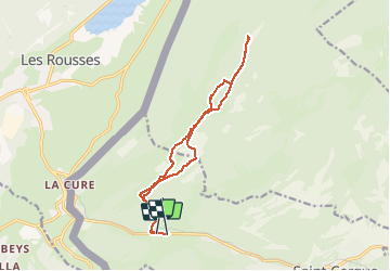

Length
13.7 km

Max alt
1495 m

Uphill gradient
458 m
Km-Effort
19.8 km

Min alt
1196 m

Downhill gradient
463 m
Boucle
No
Creation date :
2018-04-17 17:10:18.677
Updated on :
2018-04-17 17:10:18.677
--
Difficulty : Unknown

FREE GPS app for hiking
 SityTrail
IGN / Geographical institutes
SityTrail Plus
The world is yours!
About
Trail Snowshoes of 13.7 km to be discovered at Vaud, District de Nyon, Saint-Cergue. This trail is proposed by UDGI54.
Description
VERSION HIVER 01 2018 ASSEZ DIFFICILE PASSAGES EN NEIGE PROFONDE
Positioning
Country:
Switzerland
Region :
Vaud
Department/Province :
District de Nyon
Municipality :
Saint-Cergue
Location:
Unknown
Start:(Dec)
Start:(UTM)
277392 ; 5148616 (32T) N.
Comments