


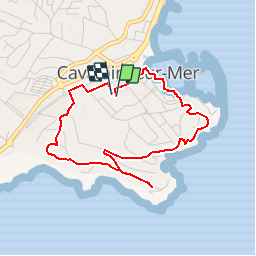
Cavalaire - Cap de la Vigie

toporient
User

Length
4.1 km

Max alt
73 m

Uphill gradient
96 m
Km-Effort
5.4 km

Min alt
1 m

Downhill gradient
96 m
Boucle
Yes
Creation date :
2018-04-17 17:37:09.594
Updated on :
2018-04-17 17:37:09.594
1h11
Difficulty : Easy

FREE GPS app for hiking
 SityTrail
IGN / Geographical institutes
SityTrail Plus
The world is yours!
About
Trail Walking of 4.1 km to be discovered at Provence-Alpes-Côte d'Azur, Var, Cavalaire-sur-Mer. This trail is proposed by toporient.
Description
Départ et retour: parking du complexe sportif Henry Gros (accès par l'Avenue Charles de Gaulle).
Vue au sud sur les Îles, du Levant, Port Cros et Porquerolles.
Positioning
Country:
France
Region :
Provence-Alpes-Côte d'Azur
Department/Province :
Var
Municipality :
Cavalaire-sur-Mer
Location:
Unknown
Start:(Dec)
Start:(UTM)
299307 ; 4782739 (32T) N.
Comments