Trail Walking Millau - le puech d'Andan(Millau) - Photo

le puech d'Andan(Millau)

 nanie
nanie

User

© OpenStreetMap contributors
Length
Length
11 km
Max alt
Max alt
887 m
Uphill gradient
Uphill gradient
524 m
Km-Effort
Km-Effort  
18 km
Min alt
Min alt
461 m
Downhill gradient
Downhill gradient
523 m
Boucle
Boucle
Yes
Creation date :
2018-04-17 17:42:49.004
Updated on :
2018-04-17 17:42:49.004

(1 Reviews)

Walking
Walking
3h45
Difficulty : Medium

Scan this QR Code to open this trail in the SityTrail application

FREE GPS app for hiking

Logo SityTrail SityTrail

IGN / Geographical institutes

Download SityTrail from the App Store Download SityTrail from Google Play

Logo SityTrail SityTrail Plus

The world is yours!

Download SityTrail from the App Store Download SityTrail from Google Play Download SityTrail on Huawei AppGallery

About

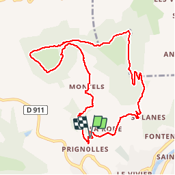
Trail Walking of 11 km to be discovered at Occitania, Aveyron, Millau. This trail is proposed by nanie.

Description

Belle randonnée à faire par beau temps Au départ de la ferme Prignolles (petit parking) Montée assez raide sur piste sans difficulté jusqu'au premier sommet (pylône)puis suivre tracé vélo et toujours suivre le bord du champ. Prendre à gauche petit sentier (glissant par temps de pluie) pour atteindre le puech. Bien contourner le champs et suivre le sentier jusqu’à la route du point de départ.    

Elevation profile

Positioning

Country:
France
Region :
Occitania
Department/Province :
Aveyron
Municipality :
Millau
Location:
Unknown
Start:(UTM)
505562 ; 4885419 (31T) N.

Comments

Please log in to post a review or rate the element


Close
My subscriptions