


rando st gwenole

association
User
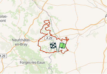

Length
124 km

Max alt
246 m

Uphill gradient
1537 m
Km-Effort
144 km

Min alt
87 m

Downhill gradient
1537 m
Boucle
No
Creation date :
2018-04-17 17:46:16.306
Updated on :
2018-04-17 17:46:16.306
5h00
Difficulty : Medium

FREE GPS app for hiking
 SityTrail
IGN / Geographical institutes
SityTrail Plus
The world is yours!
About
Trail Other activity of 124 km to be discovered at Hauts-de-France, Oise, Blargies. This trail is proposed by association.
Description
rando nocturne quad
Positioning
Country:
France
Region :
Hauts-de-France
Department/Province :
Oise
Municipality :
Blargies
Location:
Unknown
Start:(Dec)
Start:(UTM)
412626 ; 5503017 (31U) N.
Comments