


*Taverny, Forêt de Montmorency

jpcccb
User
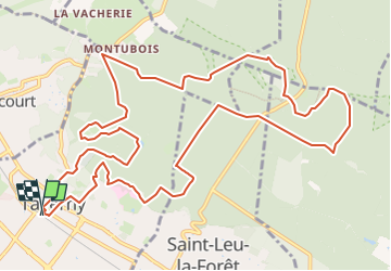

Length
14.1 km

Max alt
196 m

Uphill gradient
273 m
Km-Effort
17.7 km

Min alt
88 m

Downhill gradient
272 m
Boucle
Yes
Creation date :
2018-04-17 17:53:37.652
Updated on :
2023-05-11 15:58:17.929
4h01
Difficulty : Difficult

FREE GPS app for hiking
 SityTrail
IGN / Geographical institutes
SityTrail Plus
The world is yours!
About
Trail Walking of 14.1 km to be discovered at Ile-de-France, Val-d'Oise, Taverny. This trail is proposed by jpcccb.
Description
Forêt de Montmorency, carrefour des 6 routes, carrefour de la porte Paradis,le Camp de César, Étang Godard, le Pont du Diable.
Positioning
Country:
France
Region :
Ile-de-France
Department/Province :
Val-d'Oise
Municipality :
Taverny
Location:
Unknown
Start:(Dec)
Start:(UTM)
443097 ; 5430565 (31U) N.
Comments