


*Saint Leu la Forêt en boucle

jpcccb
User
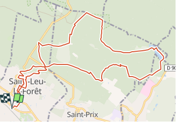

Length
13.8 km

Max alt
193 m

Uphill gradient
268 m
Km-Effort
17.3 km

Min alt
77 m

Downhill gradient
268 m
Boucle
Yes
Creation date :
2018-04-17 17:53:38.073
Updated on :
2023-05-12 11:52:25.356
3h56
Difficulty : Difficult

FREE GPS app for hiking
 SityTrail
IGN / Geographical institutes
SityTrail Plus
The world is yours!
About
Trail Walking of 13.8 km to be discovered at Ile-de-France, Val-d'Oise, Saint-Leu-la-Forêt. This trail is proposed by jpcccb.
Description
L'étang Marie, la tour du Plumet, les étangs et le château de la Chasse, carrefour de l'Homme Mort
Positioning
Country:
France
Region :
Ile-de-France
Department/Province :
Val-d'Oise
Municipality :
Saint-Leu-la-Forêt
Location:
Unknown
Start:(Dec)
Start:(UTM)
444630 ; 5429496 (31U) N.
Comments