


tour de montrognon

jpcccb
User
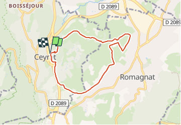

Length
7.2 km

Max alt
577 m

Uphill gradient
147 m
Km-Effort
9.1 km

Min alt
481 m

Downhill gradient
144 m
Boucle
Yes
Creation date :
2018-04-17 18:01:54.888
Updated on :
2018-04-17 18:01:54.888
--
Difficulty : Unknown

FREE GPS app for hiking
 SityTrail
IGN / Geographical institutes
SityTrail Plus
The world is yours!
About
Trail Walking of 7.2 km to be discovered at Auvergne-Rhône-Alpes, Puy-de-Dôme, Ceyrat. This trail is proposed by jpcccb.
Positioning
Country:
France
Region :
Auvergne-Rhône-Alpes
Department/Province :
Puy-de-Dôme
Municipality :
Ceyrat
Location:
Unknown
Start:(Dec)
Start:(UTM)
505357 ; 5064477 (31T) N.
Comments